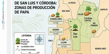
Argentina: The area cultivated with potatoes in Córdoba and San Luis grew 14.4%
A satellite study revealed in Córdoba indicated a recovery in the area dedicated to potato cultivation during the 2026 season. In Traslasierra, 9,533 hectares were concentrated, while in the area in Córdoba Capital, a total of 5,910 hectares.

Potato production in Córdoba and San Luis increased again during the 2026 season. According to a survey conducted by the National Federation of Potato Producers (FENAPP) using satellite images, both provinces reached an estimated area of 15,443 hectares, nearly 1,950 hectares more than during the previous cycle and an approximate year-on-year growth of 14.4%.
The results were presented during a recent producers’ meeting held at Espacio San Carlos in the city of Córdoba. The event was organized by FENAPP, the Córdoba branch of the Argentine Agrarian Federation, and INTA Castelar.
Among those present were Marcos Blanda, Secretary of Agriculture of Córdoba; Mario Raiteri, Secretary General of Coninagro and Vice President of the National Federation of Potato Producers; Agustín Pizzichini, President of the Argentine Agrarian Federation —FAA— Córdoba Regional and Miguel Campetella —Agrarian Federation of Córdoba— and Marcelo Espinosa, manager of FENAPP.
The technical presentation was given by Leonardo Ariel German, head of the Geoinformatics Laboratory Service Area at the Climate and Water Institute of INTA Castelar. The survey, also conducted by Juan Pablo Vitale, Gonzalo Podetti, and Cynthia Waldman, allowed for the identification of planted plots, monitoring of their development, and quantification of the area occupied by the crop.
A satellite image of the crop
The survey was based on a sequence of satellite images obtained between February and June, a period that includes the main stages of the late potato cycle: planting and emergence, vegetative development, tuberization, filling, maturation and harvest.
Time-based monitoring allowed observation of changes in each plot and differentiation of potato areas from those cultivated for other agricultural activities. Based on this data, maps were created showing the location of the crops, and the area corresponding to each department was estimated.
The methodology provides a territorial measurement that surpasses estimates based solely on declarations or surveys and allows for georeferenced information to be available to analyze the evolution of production.
Traslasierra accounts for more than 60% of the surface area
The area grouped in the report under the name Traslasierra reached 9,533 hectares, equivalent to almost 62% of the entire surveyed area.
In 2025 that region registered 8,458 hectares, so the calculated growth for the new campaign was 1,075 hectares, equivalent to an increase of 12.7%.
Meanwhile, the area identified as Córdoba Capital increased from 5,038 to 5,910 hectares, an expansion of 872 hectares, or approximately 17.3%. The combined area of these two large production zones accounts for the 15,443 hectares identified in the 2026 season.
San Javier and San Alberto lead the production map
The San Javier department remained the main potato-growing area in the survey, with 3,985 hectares. San Alberto came in second, with 3,272 hectares.
Further down the list were Río Primero, with 1,892 hectares; Ayacucho, with 1,344; Santa María, with 1,123; Colón, with 987; Junín, with 931; Totoral, with 900; Capital, with 787; and Río Segundo, with 222 hectares.
The departmental distribution for 2026 was as follows:
Department Area 2026
San Javier 3,985 ha
San Alberto 3,272 ha
Río Primero 1,892 ha
Ayacucho 1,344 ha
Santa María 1,123 ha
Columbus 987 ha
Junín 931 ha
Totoral 900 ha
Capital 787 ha
Río Segundo 222 ha
Total 15,443 ha
Ayacucho, Río Primero and Colón showed the greatest expansions
The year-on-year analysis revealed significant differences between departments. Ayacucho experienced the greatest relative growth: it went from 525 to 1,344 hectares, representing an expansion of 156%.
Also noteworthy were Colón, which increased from 637 to 987 hectares, and Río Primero, which went from 1,227 to 1,892 hectares. In both cases, the increase was around 55%.
Capital grew by 20.5%, while San Alberto and San Javier advanced by 6.8% and 5.5%, respectively.
Conversely, Totoral’s area decreased from 1,321 to 900 hectares; Junín’s from 1,090 to 931; and Santa María’s from 1,201 to 1,123 hectares. No comparable data for 2025 was presented for Río Segundo.
These trends demonstrate that the overall recovery was not uniform. While some areas significantly expanded their planted area, others experienced declines that will need to be analyzed in light of water availability, production costs, crop rotation, and producers’ business decisions.
Three growth campaigns
The historical evolution included in the report shows that the area of late potatoes went through strong fluctuations since 2002. The peak of the series occurred around 2004, when the area approached 22,000 hectares.
Subsequently, sharp declines were observed during 2012, 2018, and 2023. The study links these periods to different La Niña events: the prolonged drought from 2010 to 2012, the drought of 2017 and 2018, and the so-called "triple Niña," which extended from 2020 to 2023.
After the low point recorded in 2023, the area began to recover during 2024, continued to grow in 2025 and expanded again in 2026. However, despite this recent recovery, the area still remains below the historical highs recorded during the first decades of the series.
Information to anticipate decisions
Having an accurate estimate of the surface area allows for earlier planning of the potential production volume, seed needs, irrigation requirements, input demand, storage capacity, and the supply that could reach the market.
Information is also strategic for avoiding decisions made blindly. An increase in cultivated area does not automatically guarantee improved profitability: if increased production is not accompanied by sufficient demand, storage capacity, and orderly marketing, it can put pressure on the prices received by the producer.
Therefore, satellite surveys should not be interpreted solely as a territorial measurement. They are a tool for producers, entities, and public agencies to anticipate scenarios and make decisions based on more robust information in an activity characterized by high investments, strong dependence on irrigation, and high exposure to market fluctuations.
Fuente: Fenapp