Bélgica: Remote Sensing Platform for the Belgian Potato Chain
In the past few years, a true revolution has taken place in the satellite business. Hundreds of Earth Observation satellites have been launched and are in orbit today, taking pictures of our planet on a daily – sometimes hourly – basis.
A lot of the ESA satellite images are freely available. At the same time, prices for images taken by commercial satellite operators are also dropping. All this results in thousands of gigabytes of easily navigated data that opens up a world of possibilities for, amongst others, agricultural applications.
BRINGING SPACE TECHNOLOGY DOWN TO THE POTATO FIELDS
To start with, it is now possible to keep an eye on every field everywhere in the world. Information can be derived from satellite imagery. For example, it’s possible to calculate a reliable indicator of a crop’s productivity (fAPAR). Thanks to the commonly available high resolution satellite data, you can now derive the productivity indicator for every spot in the field and even tell farmers which parts of theirs field need attention. By combining this satellite data with the weather and soil data, it is even possible to provide meaningful information throughout the season on the development and health of the potatoes in every single field.
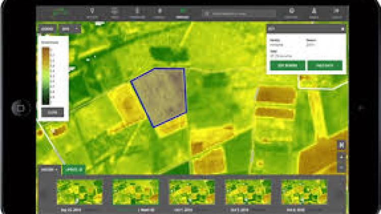
ONLINE TOOL TO MONITOR AND IMPROVE YOUR POTATO CROPS
The Belgian potato processing industry is one of the biggest exporter of frozen potato products in the world preceding the Netherlands, Canada and the United States. To safeguard this position and allow the industry to grow, they need to be able to increase potato yields in a sustainable way.
WathITgrow is an online platform for the Belgian potato sector to monitor and increase potato yields in a sustainable way. watchITgrow allows potato growers, traders and processors to access data and information on the growth of their potato crops.
WatchITgrow is the first platform to combine several types of data. Through the combination of satellite and drone images, weather and soil data and yield prediction models, the potato sector can consult, in a quick and efficient way, the correct information on one or multiple potato fields.
By using watchITgrow, you are able to:
- access more and more accurate information on the state of the crop
- better monitor the potato crop in function of growth, health status and development
- improve yields and estimate the harvest date and yields during the season
- map spatial variability within the field
- reduce production and quality losses
WatchITgrow is a beautiful example of how research can be turned into a user-friendly platform to support the industry.
These kind of innovative and sustainable technologies will be presented at G-STIC 2018. Romain Cools, CEO of the World Potato Congress inc., will be talking about Open Data and Business Models on November 29.
Romain Cools is active for more than 25 years in the Belgian, European and global potato sector. Since 2018 he became president / CEO of the World Potato Congress inc., an NGO which aims to be a premier network organization for the global potato sector. He took the initiative to set up partnerships with partners in the developing world to set up potato value chains, which has resulted in the WPC toolbox.
Fuente: gstic.org


